- SURVEY PROJECT WORKS
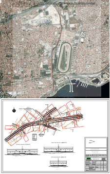
- Railroad Highways and State Roads Projects
- Big-scale and Small-scale Artistic Structures Projects
- Tunnel Projects
- Soil Research Works
- Infrastructure Projects
- DIGITAL READY MAP PREPARATION
These are the studies whereby the topographical structure and ready
status of the land and the ready structure can be perceived and utilized
by the computer.
- Determination of the Study Area
- Triangulation, Polygon and leveling: Preparation of the Reconnaissance Survey Canvases
- Triangulation, Polygon and leveling: Construction of the Facilities, Benchmarking and Taking Measurements
- Triangulation, Polygon and leveling: Preparation of Final Canvases
- Taking Detail Measurements at Residential and Non-residential site
- Calculation, chart Plotting and Drawing Works
- DIGITAL CADASTRAL MAP PREPARATION
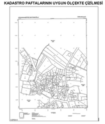
Drawing the Cadastral Map Section at an Appropriate Scale
Land Purchase and Arrangement of Measurement Charts
Our company has become eminent with totally twelve projects where the maps were digitized, property data updated and transferred into electronic environment.
- Determination of the Study Area Boundaries
- Preparation of the Reconnaissance Survey Canvases for the Ground Control Points
- Construction of the Ground Facilities, Benchmarking and taking measurements for the Ground Control Poinjts
- Preparation of Final Canvases
- Measurement of the Boundaries of the Cadastre Study Area
- Island Sectioning and Charting Works
- Limiting, Determination and Measurement Works for the Immovable Properties
- Making Area Calculations
- Drawing of Map Sections
- Preparation of the Hang Notice and Announcement
- Filling out the Deed Logs
- Issuing of Scientific Dossiers and Deeds
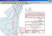
- Takbis (Deed and Cadastre Information System)
- UVDF (National Data Exchange Format)
- PREPARATION OF EXPROPRIATION PLANS
Our company is continuing its works regarding the public works plan implementation on the private property lands; governmental structures, schools, roads, plants, parks, parking lots, green areas, children playgrounds, lots, slaughter houses, market places, public transport stations, terminals, etc. official and public service areas.
- Determination of Ground Control Points and Construction of Facilities
- Preparation of Canvases
- Detail Receipt
- Determination of Expropriation Areas according to the prepared projects
- Determination of Mast Locations and Right of Way Areas at Tedaş Expropriation PTL Projects
- Formation of the Cadastral Base (Property Status)
- Receiving Property Data from the Deed Office
- Making Expropriation Calculations
- Preperation of Declerations and Building Survey Charts
- Preperation of Expropration Plans
- GPS/ REMOTE SENSING
The latest state-of-art GPS (Global Positioning System) equipment at our company are the devices that process the signals they receive from the satellites at certain orbits and rather very accurately calculate the present position. These systems can also provide the elevation data, velocity (if we are in motion), the distance to a pre-determined point and other similar information, in addition to the coordinates of the present location. At the field surveys conducted to examine a point on satellite image or to obtain the coordinates of the data entered to GIS database, GPS equipment are utilized to accurately locate the place of the relevant point.
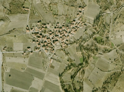
- PHOTOGRAMMETRIC MAPS
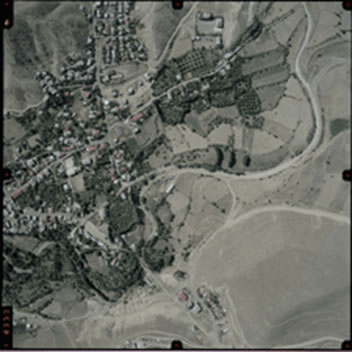
With the help of image perception systems, our company will continue to advance with its studies covering the obtaining, processing, recording, measurement, analysis and presentation of the reliable information regarding the earth surface, surrounding and other physical objects, by using the state of art equipment and its specialized staff.
Photogrammetric Maps;
- Used in increasing the frequency of the geodesic country network at the country measurement
- Used at the sketching of big, medium and small-scale maps
- Used at the preparation of 1/5000 scaled cadastral maps
- Used in the preperation of regional city and public work plans
- PUBLIC WORKS IMPLEMENTATIONS

These are the plans that we prepare for the cities and urbanizing residential areas to better respond to increasing population and ever-developing needs, the utilization of the lands with maximum efficiency and preventing non-planned urbanization.
- Determination of the Application Area Boundaries
- Digitalizing the Cadastral Bases within the Application Area
- Determination, Installation and Measurements of the Ground Control Points
- Preparation of Implementation Public Works Plan
- Preparation of Distribution Schedules
- Application of the Plan on the Land
- GIS/ GEOGRAPHICAL INFORMATION SYSTEMS
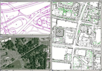
When the current importance of the information sharing pace is considered both worldwide and in Turkey, the first thing coming to the mind are the Geographical Information Systems (GIS). This system, in an integrated manner, realizes the functions of gathering, retaining, processing and presentation to user of the graphical and non-graphical data obtained based on position-based observations. Our company, which has accepted this system and advanced its studies in this direction, has aimed to reach higher levels and become eminent worldwide.
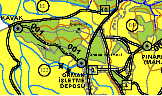
- FOREST ROADS NETWORK PLAN PREPARATION
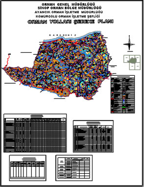
- Digitalization of 1/ 25 000 Scale Sketch Maps
- Digitalization of 1/ 25 000 Scale Existing Development Plan
- Marking the data on the sketch map in the PC environment
- Marking the existing Forest Roads on the Land on the sketch map
- Marking the existing Stabilized and Crude Village Roads and Highways on the Land on the sketch map
- Marking the existing Asphalt Village Roads and Highways on the Land on the sketch map
- Preparation of the Draft Road Network Plan in the PC environment
- Visiting the River roads on the Land and Taking Measurements
- Investigation of the Slope Road Routes on the Land
- Drawing and Coloring the Draft Road Network Plan
- Naming and Coding of the Roads in the PC environment
- Preparation and Writing the Technical Report and Schedules in the PC environment
- Plan Sketching and Coloring of the Road Network Plan in the PC environment
- Clothing, binding of the Road Network Plan, reparation of CD's
- FOREST DEVELOPMENT PLAN PREPARATION
Our company has taken significant steps in the development planning & implementation and the improvement of the forest information system. Forest development is an important forestry main science branch in the current forest operation gathering technical and administrative procedures within a time and place arrangement. In the preparation of the development plans; photogrammetric, biometry and local methods are used and our company duly performs the works of determination of the tree types, determination of old vs. young forest and determination of forest damages and diseases.
- INFRASTRUCTURE PROJECTS
- Waste water projects
- Storm water projects
- Drink water projects
- LAND COLLECTION PROJECTS
The following processes take place in the land collection projects conducted by our company:
- Transferring the proprietorship data to the PC environment: updating the deed information of the project site at the PC environment.
- Digitalizing of the sketch maps of the project site and making area control: Digitalizing of the sketch maps of the project site and determination of the parcels exceeding the area
- Installation of ground control points: Determination of the to-be-installed triangulation, polygon and leveling points and preparation of the reconnaissance canvases
- Preparation of Ready maps
- Calculation of parcel value count and transferring to the PC
- Formulation of islands
- Arrangement of village boundaries
- Interviews with the farmers: In this process, the classification map, old proprietorship list (AT1), list ordered according to last name (AT2), ready field
- Preparation of parcellation plan
- Measurement of ground control points
- Island and parcel corner applications
- Arrangement of separation diameter
- Registration processes
- Arrangement of garden boundary
- ZONING PRACTICES
These are the plans arranged by us in order to meet the needs for increasing population and developing demands, to provide maximum efficient landuse and to prevent irregular urbanization in the cities and regions becoming urbanized.
- Determination of Application Area Limits
- Digitization of Cadastral base maps in the application area
- Determining, fixing and measuring of Ground control points
- Updating the topographic maps
- Design of Development Plans
- Building Reports according to specialized customer requirements
- Application of the plan
Günka Harita © 2013. All Rights Reserved.